FAQs
Will this affect my insurance premiums?
Actions of the sea are generally not covered by home insurance policies; so it is unlikely that being within the CVA will impact your insurance. You should check with your insurer to see if you are covered for coastal erosion and recession.
Does the CVA include coastal and tidal inundation hazards?
No, the CVA incorporates the 2100 unlikely coastal erosion and recession hazard line, it does not include inundation hazards. Coastal and tidal inundation risks are captured in the relevant Flood Risk Management Studies and Plans.
What if my proposed development is partially in the CVA?
The CVA controls only apply if the proposed development / structure / activity is wholly or partially within the CVA. If for example your block is partially within the CVA but the proposed development is not within the CVA, then it does not apply. If the proposed development / structure / activity falls partially within the CVA, a Coastal Risk Management Report is likely required, this can be at the discretion of Council.
What if my appropriately qualified engineer finds that my property is not subject to coastal erosion hazards?
If your appropriately qualified engineer finds that your property is not subject to coastal hazards for the design life of the development, Council will not require any further information from you. The engineer would however, need to justify and provide evidence of why coastal erosion and recession risks are not relevant to the development over the design life (i.e. evidence of underlying bedrock, site specific coastal erosion hazard assessment etc.).
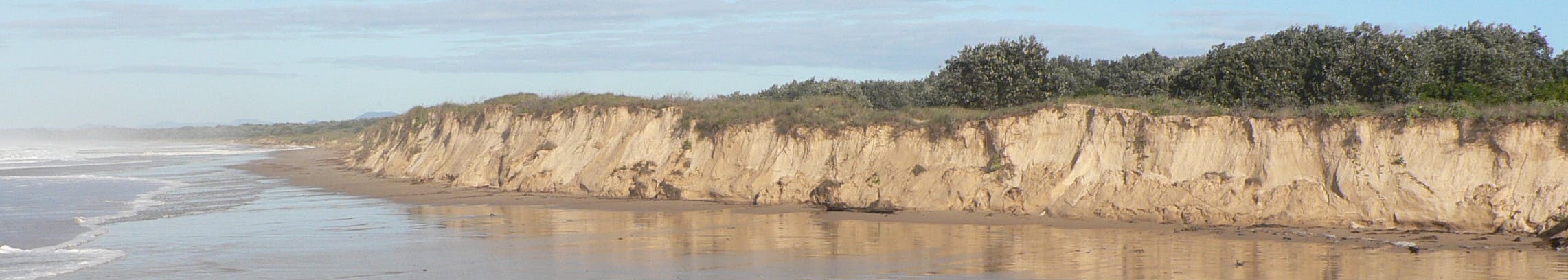
It is important to note that the CVA was mapped using modelling across the entire Coffs Harbour coast line. The mapping is designed to act as a flag for areas that may be impacted by coastal erosion and recession hazards for up to a 2100 year planning period. Individual Coastal Risk Management Reports may look at individual developments or land parcels in greater detail, with more site specific data to further understand the risks.
What do I need to do if my property is already developed in the CVA?
Nothing, the CVA only applies to new developments.
What if I want to construct a minor building, structure or activity in the CVA?
The requirements of the CVA may not apply to minor buildings, structures and activities (at the discretion of Council). Minor buildings, structures and activities considered acceptable in the CVA may include (but are not necessarily limited to) the following:
Aquaculture; Boat building and repair facilities; Boat launching ramps; Boat sheds; Charter and tourism boating facilities; Coastal protection Works; Emergency services facilities required for the operations of Surf Life Saving New South Wales or Volunteer Marine Rescue NSW; Environmental facilities; Environmental protection works; Flood mitigation works; Flood protection Works; Freight transport facilities; Jetties; Kiosks (temporary/relocatable); Marinas; Markets; Mooring pens; Moorings; Oyster Aquaculture; Passenger transport facilities; Port facilities; Recreation area; Roads; Signage; Water recreation structures; Wharf or boating facilities as defined by the Coffs Harbour Local Environmental Plan 2013.
How much does a Coastal Risk Management Report Cost?
This will depend on the complexity of your development and what is required to satisfy the CVA controls. Council recommends that you obtain quotes / proposals from a range of suitably qualified engineers before confirming engagement.
What if the coastal engineer finds that my development is not able to withstand the coastal hazards for the design life of the building / structure?
Council is unlikely to support your development application.
How would Coffs Harbour City Council respond to concerns that the current mapping of hazard lines are “exaggerated”?
The Coastal Processes and Hazard Definition Study and Coastal Zone Management Plan, on which the CVA mapping is based, was developed by independent expert consultants using current scientific data and methods. Their findings were also technically peer-reviewed.
What Sea Level Rise Projections were used in the CVA mapping?
The CVA incorporates sea level rise benchmarks of 0.9m for 2100.
What other inputs were used in the coastal erosion and recession modelling?
The CVA mapping is underpinned by the 2100 unlikely coastal erosion and recession line in the Coastal Zone Management Plan 2019. This line is defined as; “maximum” beach erosion + Harbour impact +0.9m sea level rise. A further geotechnical study was undertaken in 2018, which was followed by a further review of the hazard lines. As a result of the study, hazard lines were modified in four key study areas to more accurately reflect the underlying bedrock conditions. More detail can be found on page 14 of the Coastal Zone Management Plan on Councils website (https://www.coffsharbour.nsw.gov.au/environment/our-coast/Pages/coastal_zone_management_plan.aspx).
Didn’t Council undertake a similar process in 2014?
Council did commence a Coastal Hazard Planning Controls project in 2014 however then deferred the project to allow for the NSW Coastal Reform process to unfold. With the NSW Coastal Reforms complete, and the Coffs Harbour Coastal Zone Management Plan certified, Council is now reinitiating this project in the context of the new legislation. The new development controls focus on a merit based approach rather than the previous 2014 process which placed more restrictions on development on the CVA.
Are changes being made to Planning Certificates?
No, properties seaward of the 2100 unlikely coastal erosion and recession line already have a notation on planning certificates issued under s10.7 of the Environmental Planning and Assessment Act 1979.
Where can I view the maps and associated documents?
The maps can be found via Councils online mapping tool here - https://www.coffsharbour.nsw.gov.au/Pages/Online%20Mapping.aspx
The documents are available in the viewing pane of this Have Your Say Page.
Doesn’t Council already consider coastal hazards with assessing Development Applications?
Yes, under Councils existing Coastal Zone Hazard Policy (which will be replaced by the new Coastal Vulnerability Area Policy) a coastal hazards assessment is already required for developments that may be affected by coastal processes. This project uses the same inputs but brings the framework into line with the updated state legislation, and provides more detail of what is required to be submitted with development applications in the CVA.
The latest Intergovernmental Panel on Climate Change (IPCC) suggests that sea levels may rise by more than 0.9 by 2100, are we using the right figures?
The figures are part of Council’s adopted Coastal Zone Management Plan 2019, the review of this plan is due to commence in the 23/23 financial year.