FAQs
Draft Plan of Management
- Tree planting
- Gardens
- Drainage and ground shaping
- Access
- Furniture
- Lighting
- Signs
- Picnic areas
- Playgrounds
Why is a Plan of Management Required?
The NSW Local Government Act 1993 requires local government to adopt Plans of Management for all land classified as community land. The draft PoM establishes a management framework for the land that: promotes, encourages and provides for the use of the land, and; provides facilities on the land to meet the current and future needs of the local community and the wider public.
What else is possible with this Land, under the draft Plan of Management?
The draft Plan of Management spells out various targets for the future of land, including enhancement and maintenance objectives, risk management, weed eradication and pest controls, plus targets to identify and prioritise any required or requested improvements such as:
What is proposed for 13 Manning Avenue?
The draft PoM categorises the Community Land as a Park and for Community Use. Under the draft Public Realm Strategy, the land would be further categorised as a Local Park, based on the NSW Greener Places Framework. One of the requirements for a Local Park is that 50% of the site has road frontage for access and visual surveillance. The proposed road plan (Refer to Documents section on this page) would provide road frontage, access and visual surveillance, which adds to the existing road frontage in Manning Avenue.
What is the relationship between Wongala Estate and 13 Manning Avenue?
Wongala Estate is currently managed by the Coffs Harbour and District Local Aboriginal Lands Council (LALC), which has limited funding to undertake the required and on-going maintenance. The current substandard road conditions are a barrier to achieving equality of access to essential services in this community. The road reserve into the Community Land includes drainage, kerb and gutter, footpaths, street and public space lighting, upgraded road surfaces, telecommunications and power.
What is the Roads to Home Program?
The Roads to Home program is a NSW Government DPE funded initiative designed to address the long-standing infrastructure challenges for Aboriginal Communities. It provides funding for locations such as Wongala Estate, Coffs Harbour to upgrade road, water and sewer infrastructure to City standards and subsequently dedicate it to Local Government as with other subdivisions. This will improve access to services and ensure long-term maintenance.
Community Land
- Natural area, being further categorised as: - bushland - wetland - escarpment – watercourse - foreshore
- Sportsground
- Park
- Area of Cultural Significance
- General Community Use.
What is Community Land?
Community Land is land that is made available by local government in NSW for use by the general public.
The Local Government Act 1993 requires that community land is categorised based on its predominant use; as one (or more) of the following:
Community Land cannot be sold, exchanged or disposed of in any way by a Council. Community Land may be leased, however there are restrictions on the granting of leases and licences for how that Community Land must be used.
What is proposed for the Community Land?
The Coffs Harbour Districts Local Aboriginal Land Council (LALC) has secured stimulus grant funding to upgrade the road infrastructure, subject to the Development Application (DA) process. The LALC has submitted an initial DA to subdivide the existing site into 18 lots and upgrade services within the City's controlled land. To enable this to happen and for the road plan to meet the required standards, it would be partly located on the western side of the adjoining community land. Under the terms of section 47F LG Act, the community land requires a specific plan of management stating the location of a public road as a permitted use of the land (Section 5 of the draft PoM).
What is the nature of the Community Land?
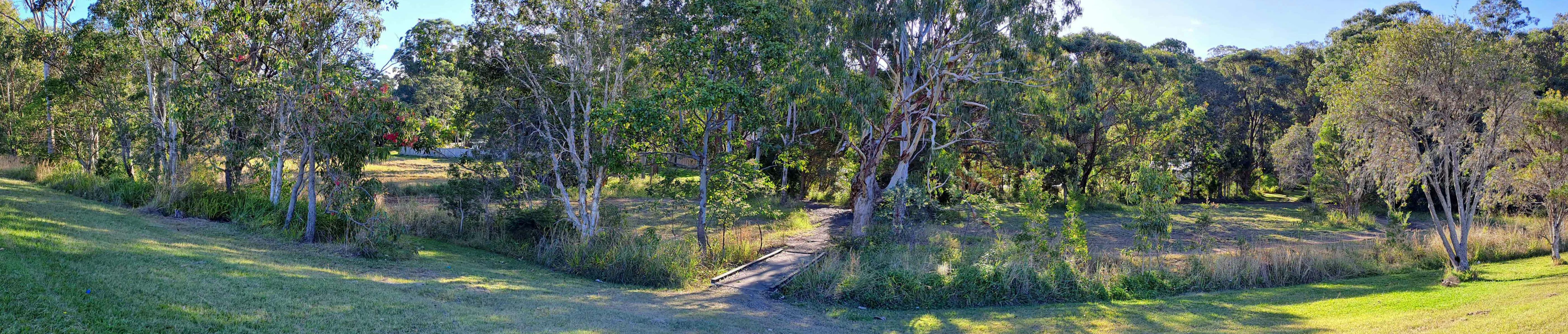
The 13 Manning Avenue site is legally described as Lot 1 in DP119056. The site has a land size of 2.987ha, split across both portions of the allotment. The site is split by a portion of Wongala Drive, which is a public road. The site also has road frontage to Manning Avenue.
The property has an under-lining land zoning of RE1 – Public Recreation under the Coffs Harbour Local Environmental Plan 2013. The site is also identified as being a City Controlled Property and is identified to be Community Land under the Local Government Act 1993.
The site is a natural low point in the area, and therefore, operates as a natural stormwater detention basin. The site also has several water utilities within the boundaries, including a surface inlet pit (which sits adjacent to Arthur Street) and several stormwater outlet pits that service the surrounding residential area.
Is it okay to build a road on Community Land?
Yes, under certain circumstances part of Community Land may be dedicated as a public road.
The NSW Local Government Act, 1993, Section 47 states:
1) Community land may not be dedicated as a public road under section 10 of the Roads Act 1993 unless:
a) the road is necessary to facilitate enjoyment of the area of community land on which the road is to be constructed or of any facility on that land, and
b) the council has considered means of access other than public road access to facilitate that enjoyment, and
c) there is a plan of management applying only to the land concerned and provision of the public road is expressly authorised in the plan of management.
Land use classifications
- Use of land for operational infrastructure.
- Construction and dedication of new public roads (as indicated on the plan in Appendix A) to facilitate more direct public road access to the western side of the reserve.
What does a Park Classification mean?
The core objectives for management of Community Land categorised as Park are:
a) to encourage, promote and facilitate recreational, cultural, social and educational pastimes and activities, and
b) to provide for passive recreational activities or pastimes and for the casual playing of games, and
c) to improve the land in such a way as to promote and facilitate its use to achieve the other core objectives for its management.
What does Community Use Classification mean?
The core objectives for management of community land categorised as General Community Use are to promote, encourage and provide for the use of the land, and to provide facilities on the land, to meet the current and future needs of the local community and of the wider public:
a) in relation to public recreation and the physical, cultural, social and intellectual welfare or development of individual members of the public, and
b) in relation to purposes for which a lease, licence or other estate may be granted in respect of the land (other than the provision of public utilities and works associated with or ancillary to public utilities).
Are there any other uses permitted for this land?
The draft PoM for 13 Manning Avenue includes Special Provisions (refer to Section 5 of the draft Plan.
Authorised improvements would include Public operation infrastructure – including drains, pump stations, bored, basins, public roads.
Authorised uses by the City of Coffs Harbour would include: